

No. 95
September 10, 2026
1 time
PUBLIC NOTICE
Published in the Newcastle Pacer on Thursday, September 10, 2026
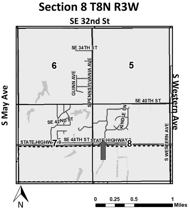
Notice is hereby given of the intent to rezone a parcel of land in that part of Newcastle described as follows:
A tract of land out of the Southwest Quarter of the Southwest Quarter of the Northwest Quarter (SW/4 SW/4 NW/4) of Section Eight (8), Township Eight (8) North, Range Three (3) West McClain County, Oklahoma, described by metes and bounds as follows:
Commencing at the SW/corner of the SW/4 SW/4 NW/4 of Section 8, thence N 89°52’26” E along the South line of the SW/4 SW/4 NW/4 for a distance of 510.68 feet to the Point of Beginning; thence N 00°01’45” W for a distance of 208.68 feet; thence N 89°52’56” E for a distance of 153.65 feet to a point on the East line of the SW/4 SW/4 NW/4; thence S 00°01’32” E along the East line of the SW/4 SW/4 NW/4 for a distance of 208.68 feet to a point on the South line of the SW/4 SW/4 NW/4; thence S 89°52’26” W along said South line for a distance of 153.63 feet to the Point of Beginning.
Containing 32,066Sq. Ft. or 0.7361 Acres, more or less. (Walker R2026-012)
This property is located at: 3145 SE 44th Street, Newcastle, Oklahoma.
And is to be rezoned from C-C-2 (Community Commercial District) to PUD (Planned Unit Development and is owned by Jeramiah & Aimee Walker.
Anyone having any objection to this move will be heard at the regularly scheduled meeting of the Newcastle Planning & Zoning Commission on September 28, 2026, at 6:00 p.m., and the City Council on October 13, 2026, at 6:00 p.m. Both meetings will be held in the Newcastle Multi-Purpose Center, 705 NW 10th Street, Newcastle, Oklahoma.
Gordon Harness
Chairman, Planning
& Zoning Commission
ATTEST:
Kathy James, Planning Secretary
Disclaimer: This vicinity map is for informational purposes only and is NOT suitable for legal, surveying, or engineering purposes. The City of Newcastle is not responsible for any errors, deficiencies, defects, omissions, or inaccuracies in the data.
__________
No. 96
September 10, 2026
1 time
PUBLIC NOTICE
Published in the Newcastle Pacer on Thursday, September 10, 2026
Notice is hereby given of a Notice for Use Permitted on Review for a parcel of land in that part of Newcastle described as follows:
LEASE AREA HEMPHILL TOWERS, LLC HWY9-PENN:
All that tract or parcel of land lying and being in the Northwest¼ of Section 8, Township 8 North, Range 3 West, of the Indian Meridian, City of Newcastle, McClain County, Oklahoma, and being a portion of the lands of Storage ‘R’ Us, LLC, as recorded in Deed Book 2408, Page 825, being depicted as Lot 1, Block 1 of the Final Plat of Storage ‘R’ Us, LLC, on the plat thereof as recorded in Plat Book 2987, Page 591, and being more particularly described as follows:
To find the point of beginning, COMMENCE at a nail found at the Southwest corner of the Northwest ¼ of said Section 8, said nail having an Oklahoma Grid North, NAD83, South Zone Value of N=673186.3200, E=2103693.3319; thence running along the south line of said Northwest ¼, North 89°38’11” East, 843.87 feet to a point; thence leaving said south line and running along a tie line, North 00°16’50” West, 50.00 feet to a bent 3/8-inch rebar found at the southwest corner of said lands and the northerly right-of-way line of Southeast 44th Street (having a 50-foot wide public right-of-way), said 3/8-inch rebar having an Oklahoma Grid North, NAD83, South Zone Value of N=673241.6736, E=2104536.9359; thence running along said northerly right-of-way line, North 89°38’11” East, 366.81 feet to a point; thence leaving said northerly right-of-way line and running, North 00°20’56” West, 365.03 feet to a point; thence, North 89°39’04” East, 18.24 feet to a point on the Lease Area; thence running along said Lease Area, North 00°20’56” West, 25.00 feet to a point and the true POINT OF BEGINNING; Thence, North 89°39’04” East, 50.00 feet to a point; Thence, South 00°20’56” East, 50.00 feet to a point; Thence, South 89°39’04” West, 50.00 feet to a point; Thence, North 00°20’56” West, 50.00 feet a point and the POINT OF BEGINNING.
Bearings based on Oklahoma Grid North, NAD83, South Zone.
Said tract contains 0.0574 acres (2,500 square feet), more or less, as shown in a survey prepared for Hemphill Towers, LLC by POINT TO POINT LAND SURVEYORS, INC. dated January 23rd, 2026.
20’ ACCESS & UTILITY EASEMENT HEMPHILL TOWERS, LLC HWY 9-PENN:
Together with a 20-foot wide Access & Utility Easement (lying 10 feet each side of centerline), lying and being in the Northwest¼ of Section 8, Township 8 North, Range 3 West, of the Indian Meridian, City of Newcastle, McClain County, Oklahoma, and being a portion of the lands of Storage ‘R’ Us, LLC, as recorded in Deed Book 2408, Page 825, being depicted as Lot 1, Block 1 of the Final Plat of Storage ‘R’ Us, LLC, on the plat thereof as recorded in Plat Book 2987, Page 591, and being more particularly described by the following centerline data:
To find the point of beginning, COMMENCE at a nail found at the Southwest corner of the Northwest ¼ of said Section 8, said nail having an Oklahoma Grid North, NAD83, South Zone Value of N=673186.3200, E=2103693.3319; thence running along the south line of said Northwest ¼, North 89°38’11” East, 843.87 feet to a point; thence leaving said south line and running along a tie line, North 00°16’50” West, 50.00 feet to a bent 3/8-inch rebar found at the southwest corner of said lands and the northerly right-of-way line of Southeast 44th Street (having a 50-foot wide public right-of-way), said 3/8-inch rebar having an Oklahoma Grid North, NAD83, South Zone Value of N=673241.6736, E=2104536.9359; thence running along said northerly right-of-way line, North 89°38’11” East, 366.81 feet to a point and the true POINT OF BEGINNING; Thence leaving said northerly right-of-way line and running, North 00°20’56” West, 365.03 feet to a point; Thence, North 89°39’04” East, 18.24 feet to the ENDING at a point on the Lease Area.
Bearings based on Oklahoma Grid North, NAD83, South Zone.
As shown in a survey prepared for Hemphill Towers, LLC by POINT TO POINT LAND SURVEYORS, INC. dated January 23rd, 2026. (Storage R Us UPOR #2026-004)
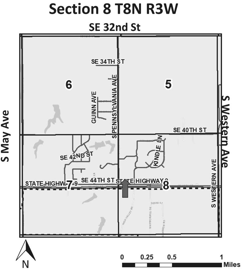
This property is located at: 3301 SE 44th Street, Newcastle, Oklahoma
And is to be reviewed for the use of Proposed construction of 150’ Cellular Communication Tower and is owned by Storage “R” Us, LLC/Hemphill Towers, LLC .
Anyone having any objection to this move will be heard at the regularly scheduled meeting of the Newcastle Planning & Zoning Commission on September 28, 2026, at 6:00 p.m., and the City Council on October 13, 2026, at 6:00 p.m. Both meetings will be held in the Newcastle Multi-Purpose Center, 705 NW 10th Street, Newcastle, Oklahoma.
Gordon Harness
Chairman, Planning
& Zoning Commission
ATTEST:
Kathy James, Planning Secretary
Disclaimer: This vicinity map is for informational purposes only and is NOT suitable for legal, surveying, or engineering purposes. The City of Newcastle is not responsible for any errors, deficiencies, defects, omissions, or inaccuracies in the data.
___________________
No. 97
September 10, 2026
1 time
PUBLIC NOTICE
Published in the Newcastle Pacer on Thursday, September 10, 2026
Notice is hereby given of a Notice for Use Permitted on Review for a parcel of land in that part of Newcastle described as follows:
A tract of land lying in the Southwest Quarter (SW¼) of Section Twenty-two (22), Township Nine (9) North, Range Four (4) West of the Indian Meridian, McClain County, Oklahoma, being more particularly described as follows: Commencing at the SE/corner of the Southwest Quarter (SW¼) of Section 22; thence N 00°13’44” E, along the East line of said SW¼, a distance of 1546.30 feet to the Point of Beginning; thence S 89°47’07” W a distance of 327.20 feet; thence N 00°13’44” E, parallel with the East line of said SW¼, a distance of 240.00 feet; thence N 89°47’07” E a distance of 327.20 feet to the East line of said SW¼; thence S 00°13’44” W, along said East line, a distance of 240.00 feet to the Point of Beginning. (Bass-Ward UPOR#2024-003)
This property is located at: 1214 S. Dickerson, Newcastle, Oklahoma
And is to be reviewed for the use of Short-Term Vacation Rental and is owned by Audie Bass-Ward & Richard Bass.
Anyone having objections to this move will be heard at the regularly scheduled meeting of the Newcastle Planning & Zoning Commission on September 28, 2026, at 6:00 p.m., and the City Council on October 13, 2026, at 6:00 p.m. Both meetings will be held in the Newcastle Multi-Purpose Center, 705 NW 10th Street, Newcastle, Oklahoma.
Gordon Harness
Chairman, Planning
& Zoning Commission
ATTEST:
Kathy James, Planning Secretary
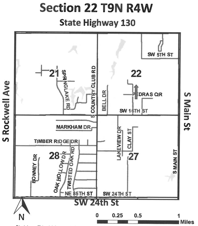
Disclaimer: This vicinity map is for informational purposes only and is NOT suitable for legal, surveying, or engineering purposes. The City of Newcastle is not responsible for any errors, deficiencies, defects, omissions, or inaccuracies in the data.
_____________________
OKLAHOMA TURNPIKE AUTHORITY
ADVERTISEMENT FOR PROPOSAL
For Electrical Services and Repairs
ITB 2026-009
OKLAHOMA TURNPIKE AUTHORITY NOW REQUIRES ONLINE
BIDDING. To sign up for online bidding, contact Bid Express at www.
BidExpress.com/users/new or call (888) 352-2439. All bids must be
submitted over the Internet via Bid Express to the Oklahoma Turnpike
Authority.
NO BID WILL BE ACCEPTED AFTER 10:00 A.M. CST on the scheduled
bid opening date: Tuesday, September 29, 2026. Proposals will be publicly
opened at 11 :00 A.M. via Zoom:
Join Zoom Meeting
One tap mobile: US: + 16692545252 1659063056# or
+14154494000 1659063056#
Meeting URL: https://www.zoomgov.com/j/ 1659063056?
pwd=bNLgs4tPaWipK61bw1 Uaa99F1 fgGV0.1
Meeting ID: 165 906 3056
Passcode:914351
I. No bids which are tied to. or contingent upon, other work with the
Oklahoma Turnpike Authority will be accepted.
II. Bidders shall familiarize themselves with the conditions and shall
understand that full cooperation in executing the requirements of the
Scope of Work is expected.
Ill. All contractors that desire to provide the OTA with manual service
work are required by state statute to complete an employee E-Verify
Form.
IV. The work to be performed under ITB 2026-009 consists of:
The Oklahoma Turnpike Authority (OTA) invites bids from qualified,
responsible, and properly licensed electrical contractors to provide
on-call electrical repair and related services, including all required
labor and materials, at OTA maintained properties and locations
including Oklahoma's 12 turnpikes: Cherokee, Chickasaw,
Cimarron, Creek, Gilcrease, H.E. Bailey, Indian Nation, Kickapoo,
John Kilpatrick, Muskogee, Turner, and Will Rogers.
V. In awarding the contract the Oklahoma Turnpike Authority reserves
the right to reject any and all bids, to waive informalities, and to act
for the best interest of the OTA without technicalities as to procedure.
VI. Policies of insurance will not be cancelled without first giving the
OTA 30 calendar days' advance notice. This statement must be on
the Description of Operations section of the Certificate of Insurance.
VII. Upon award of contract to a successful bidder, the contract will be
completely and correctly executed by the contractor and returned to
the OTA within twenty (20) calendar days from date of award. The
OTA will have thirty (30) working days from the date of award to
complete its execution of the contract.