
No. 05
February 5, 2026
1 time
PUBLIC NOTICE
Published in the Newcastle Pacer on Thursday, February 5, 2026
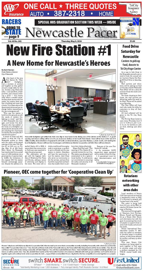
Notice is hereby given of the intent to rezone a parcel of land in that part of Newcastle described as follows:
A tract of land being a part of the Northwest Quarter (NW/4) of Section Thirteen (13), Township Nine (9) North, Range Four (4) West of the Indian Meridian, McClain County, Oklahoma, being more particularly described as follows:
Commencing at the NW/Corner of the Northwest Quarter (NW/4) of said Section Thirteen (13); thence South 89°52’19” East on the North line of said Northwest Quarter (NW/4) a distance of 991.08 feet to the point of beginning. Thence continuing S 89°52’19” East a distance of 495.50 feet to a point; Thence S 00°08’03” West a distance of 1,762.60 feet to a point; Thence N 89°47’18” West a distance of 495.17 feet to a point; Thence N 00°07’24” East a distance of 1,765.88 feet to the point of beginning (Marquier R2026-005)
This property is located at: 1840 NE 16th Street, Newcastle, Oklahoma.
And is to be rezoned from I-R (Restricted Light Manufacturing and Warehousing District) to I-H-2 (Heavy Industry District) and is owned by Howard & Gena Marquier, husband and wife.
Anyone having any objection to this move will be heard at the regularly scheduled meeting of the Newcastle Planning & Zoning Commission on February 23, 2026, at 6:00 p.m., and the City Council on March 9, 2026, at 6:00 p.m. Both meetings will be held in the Newcastle Multi-Purpose Center, 705 NW 10th Street, Newcastle, Oklahoma.
Gordon Harness
Chairman, Planning &
Zoning Commission
Disclaimer: This vicinity map is for informational purposes only and is NOT suitable for legal, surveying, or engineering purposes. The City of Newcastle is not responsible for any errors, deficiencies, defects, omissions, or inaccuracies in the data.
ATTEST:
Kathy James, Planning Secretary
___________________
No. 06
February 5, 2026
1 time
PUBLIC NOTICE
Published in the Newcastle Pacer on Thursday, February 5, 2026
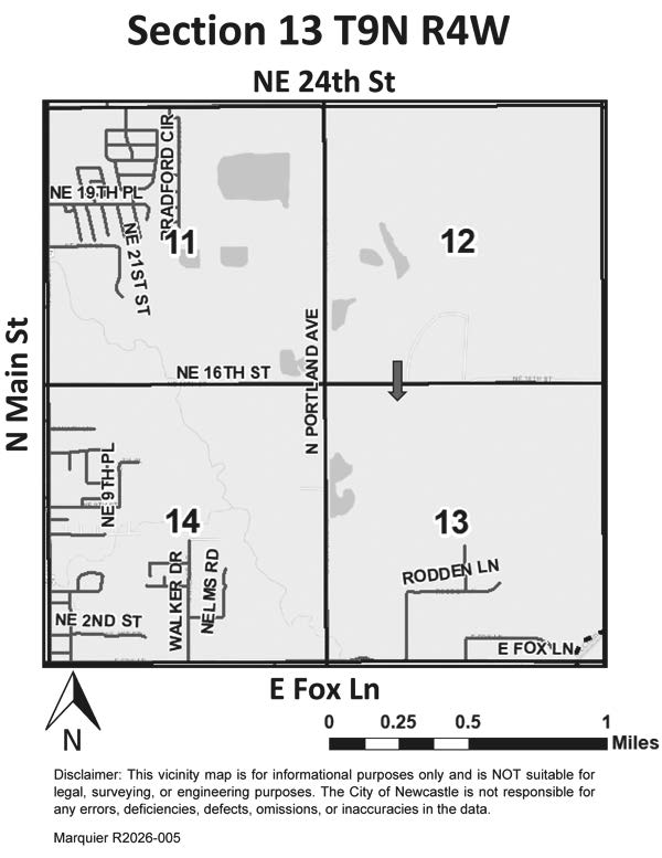
Notice is hereby given of the intent to rezone a parcel of land in that part of Newcastle described as follows:
A tract of land being a part of the Northwest Quarter (NW/4) of Section Thirteen (13), Township Nine (9) North, Range Four (4) West of the Indian Meridian, McClain County, Oklahoma, being more particularly described as follows:
Commencing at the NW/Corner of said Section 13; thence S 89°52’19” E a distance of 743.58 feet to the Point of Beginning; thence S 89°52’19” E a distance of 247.50 feet to a point being on the East line of the W/2 E/2 W/2 NW/4; thence S 00°07’24” W a distance of 881.25 feet to a point; thence N 89°47’18” W a distance of 247.50 feet to a point; thence N 00°07’24” E a distance of 880.88 feet to the Point of Beginning. (IS3 Holding R2026-004)
This property is located at: 1800 NE 16th Street, Newcastle, Oklahoma.
And is to be rezoned from I-R (Restricted Light Manufacturing and Warehousing District) to I-H-2 (Heavy Industry District) and is owned by IS3 Holdings, LLC, an Oklahoma Limited Liability Company .
Anyone having any objection to this move will be heard at the regularly scheduled meeting of the Newcastle Planning & Zoning Commission on February 23, 2026, at 6:00 p.m., and the City Council on March 9, 2026, at 6:00 p.m. Both meetings will be held in the Newcastle Multi-Purpose Center, 705 NW 10th Street, Newcastle, Oklahoma.
Gordon Harness
Chairman, Planning &
Zoning Commission
ATTEST:
Kathy James, Planning Secretary
Disclaimer: This vicinity map is for informational purposes only and is NOT suitable for legal, surveying, or engineering purposes. The City of Newcastle is not responsible for any errors, deficiencies, defects, omissions, or inaccuracies in the data.
______________
No. 07
September 12, 2023
1 time
PUBLIC NOTICE
Published in the Newcastle Pacer on Thursday, February 5, 2026
Notice is hereby given of the intent to rezone a parcel of land in that part of Newcastle described as follows:
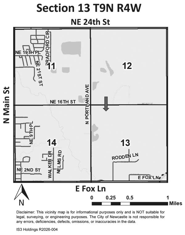
Part of the North Half (N/2) of the Southwest Quarter (SW/4) of Section Fourteen (14), Township Nine (9) North, Range Four (4) West, I.M., McClain County, Oklahoma, being more particularly described as follows: Commencing at the Northwest Corner of said N/2 SW/4; thence East along the North line of said N/2 SW/4 a distance of 1001.30 feet to the point of beginning; thence East 344.68 feet; thence South 210 feet; thence West 345.95 feet; thence North 210 feet to the point of beginning. (Drews R2026-003)
This property is located at: 303 Naomi Lane, Newcastle, Oklahoma.
And is to be rezoned from C-C-2 (Community Commercial District) to R-F-2 (Two Family Residential District) and is owned by Leisha Drews and Stephen Drews.
Anyone having any objection to this move will be heard at the regularly scheduled meeting of the Newcastle Planning & Zoning Commission on February 23, 2026, at 6:00 p.m., and the City Council on March 9, 2026, at 6:00 p.m. Both meetings will be held in the Newcastle Multi-Purpose Center, 705 NW 10th Street, Newcastle, Oklahoma.
Gordon Harness
Chairman, Planning
& Zoning Commission
ATTEST:
Kathy James, Planning Secretary
Disclaimer: This vicinity map is for informational purposes only and is NOT suitable for legal, surveying, or engineering purposes. The City of Newcastle is not responsible for any errors, deficiencies, defects, omissions, or inaccuracies in the data.
________________
No. 08
February 5, 2026
1 time
PUBLIC NOTICE
Published in the Newcastle Pacer on Thursday, February 5, 2026
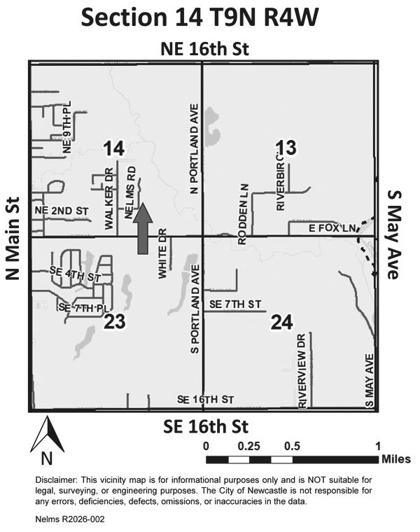
Notice is hereby given of the intent to rezone a parcel of land in that part of Newcastle described as follows:
That part of the Southeast Quarter of Section 14, Township 9 North, Range 4 West of the I.M., and described as follows: Beginning at a point 1320 ft. North and 689 ft. East of the Southwest Corner, of said SE/4; thence East 629 ft.; thence North 331 ft.; thence West 629 ft.; thence South 331 ft. to the point of beginning, known as Trust No. 3. (Nelms R2026-002)
This property is located at: 404 Nelms Road, Newcastle, Oklahoma.
And is to be rezoned from A (Agriculture) to E-1 (Suburban Estate Residential) and is owned by Beverly Nelms.
Anyone having any objection to this move will be heard at the regularly scheduled meeting of the Newcastle Planning & Zoning Commission on February 23, 2026, at 6:00 p.m., and the City Council on March 9, 2026, at 6:00 p.m. Both meetings will be held in the Newcastle Multi-Purpose Center, 705 NW 10th Street, Newcastle, Oklahoma.
Gordon Harness
Chairman, Planning &
Zoning Commission
ATTEST:
Kathy James, Planning Secretary
Disclaimer: This vicinity map is for informational purposes only and is NOT suitable for legal, surveying, or engineering purposes. The City of Newcastle is not responsible for any errors, deficiencies, defects, omissions, or inaccuracies in the data.
__________________________________________________________