
No. 101
Sept. 25, Oct. 2, Oct. 9, Oct. 16, 2025
4 times
PUBLIC NOTICE
Let it be known to every one in the United States of America and the Whole World that McClain County, Oklahoma, resident Sandra Michelle Sandwell, from this day August 23, 2025, was ordained the Title of Priestess and Dame in the Holy Catholic Church of the East in Brazil and the Sacred Medical Order St. John Nevis/ St. Christopher, Puerto Rico, Curacao and Ecuador.
Let it also be known that from this day of August 23, 2025, that Sandra Michelle Sandwell was bestowed the Title of Protected Persons-IHL Decree of the Ordination No. 012/2025.
This is to affirm that Ascended Hope Ministry, Priory No. 238 (508c1a) is duly recognized as a Priory and sanctioned by ecclesiastical decree under the Sacred Medical Order of The Church of Hope, under the pro-tection of the Holy Catholic Church of the East in Brazil.
Ascended Hope Health Ministry functions as a faith-based ministry., operating in alignment with the Sacred Medical Order of the Knights of Hope, with the mission to serve, guide, and uphold principles of hope, spiritual wellness, and holistic care.
From this day of August 23, 2025, and hence forth the Official Title Bestowed shall read: Dame Rev. Mother Michelle Sandwell. This title and ordination is bestowed by: Epus Charles McWilliams: Arch Bishop and Grand Master and Mar Basilius Adao Pereira: Metropolitan Arch Bishop of the Holy Catholic Church of the East in Brazil.
In the name of the Father and of the Son and of the Holy Spirit. Amen.
____________________________________________________________________
No. 102
Sept. 25, Oct. 2, Oct. 9, 2025
3 times
NOTICE BY PUBLICATION
Case No: CS-2025-451
THE STATE OF OKLAHOMA TO: Donald Keith Jones, Deceased and unknown successors,
The above stated Unknown Successors of the Defendant will take notice that the Plaintiff, TINKER FEDERAL CREDIT UNION, a Federally Chartered Union, filed its Petition in the District Court of McClain County, State of Oklahoma, against the above named Defendants, and said Defendants must answer said Petition on or before the 3rd day of November, or said Petition will be taken as true, and a judgment will be rendered on the promissory note and credit obligation against the Defendants as to the above property, as to DONALD KEITH JONES, Deceased and unknown successors, and adjudging that default has been made in said note and credit agreement and that Plaintiff have a valid, judgment lien on said real estate in the total amounts of $6,864.72 together with interest after judgment on the statutory rate on the balance until paid, together with attorney’s fees, and all costs of this action, and declaration of judgment lien, for all which judgment will be taken.
MCCLAIN COUNTY
COURT CLERK
By /s/ Karen Weltmer
HALL & LUDLAM, PLLC
ATTORNEYS
210 PARK AVE., STE. 3001
OKLAHOMA CITY, OK 73102
(405) 600-9500
(405) 871-5403 (FAX)
______________________________________________________________________
No. 105
October 2, October 9, 2025
2 times
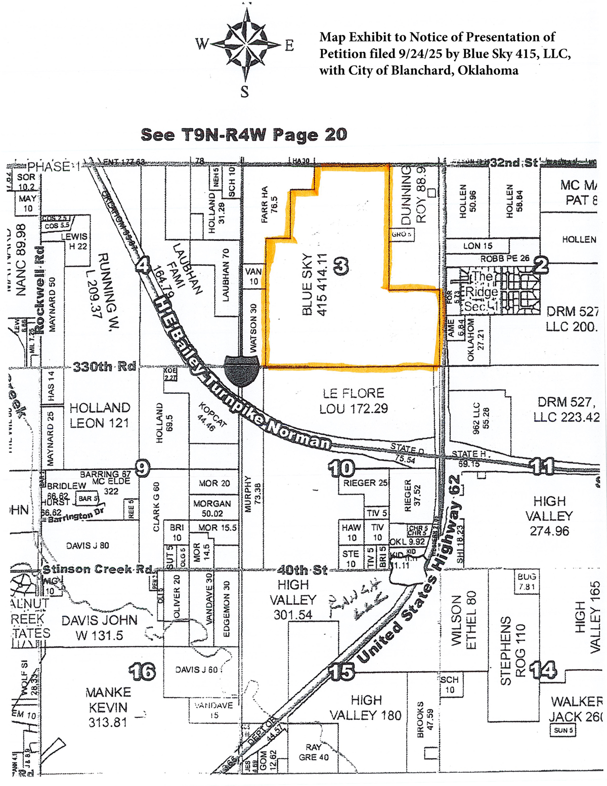
NOTICE OF PRESENTATION OF
PETITION SUBMITTED TO DETACH
(11 O.S. § 21-105)
Petitioner, BLUE SKY 415, LLC, an Oklahoma Limited Liability Company (“Petitioner”), hereby gives notice that it has presented and submitted its petitions to detach the property described hereinafter (the “Petitions”) to the Clerk of the City of Blanchard, Oklahoma, September 24, 2025, all in accordance with 11 O.S. § 21-105. Petitioner further provides notice to the public as follows:
1. An unsigned copy of the Petitions have been filed with the Clerk of the City of Blanchard, Oklahoma, within ninety (90) days of date of this publication.
2. Copies of the separately signed Petitions have been filed with the Clerk of the City of Blanchard, Oklahoma, on September 24, 2025.
3. This Notice of said submission of the Petition is being provided in accordance with Oklahoma law including, without limitation, 11 O.S. § 21-110 and § 21-105.
4. The property in which Petitioner is seeking to detach in the filed petitions is legally described as follows:
The West Half of the East Half (W½ E½ ) and the Southeast Quarter of the Southeast Quarter (SE¼ SE¼) and the South Half of the Northeast Quarter of the Southeast Quarter (S½NE¼ SE¼ ) and the East Three Quarters of the Southwest Quarter (E3/4 SW ¼) and the Southeast Quarter of the Southwest Quarter of the Northwest Quarter (SE¼ SW¼ NW¼ ) and the Southeast Quarter of the Northwest Quarter (SE¼ NW¼ ) and the South Half of the Northeast Quarter of the Northwest Quarter (S½ NE¼ NW¼ ) and the Northeast Quarter of the Northeast Quarter of the Northwest Quarter (NE¼ NE ¼ NW ¼ ) of Section Three (3), Township Eight (8) North, Range Four (4) West of the I.M., McClain County, Oklahoma.
5. The Petitioner further states that the above referenced Petitioner’s property was annexed in four installments by the City of Blanchard pursuant to the City of Blanchard Ordinances No. 683 adopted on October 23, 2018; Ordinance No. 1984-06 adopted February 28, 1984; Ordinance No. 1984-07 adopted March 6, 1984; and Ordinance No. 1991-05 adopted August 29, 1991. Only a portion of the first three ordinance tracts are owned by Petitioner; all of No. 683 is owned by Petitioner.
6. The Petitioner’s property sought to be de-annexed contains 417.55 acres, more or less, as described in the above legal description and is reflected in the map attached hereto as being part of Section 3, Township 8 North, Range 4 West of the I.M., McClain County, Oklahoma.
/s/ Isaac Treadaway
Isaac Treadaway, OBA #35345
LIND TREADAWAY, PLLC
108 N. Second Avenue
Purcell, Oklahoma 73080
Telephone (405) 442-0483
[email protected]
ATTORNEY FOR PETITIONER
_______________________________________________________________
No. 106
October 2, October 9, 2025
2 times
In the District Court of
McClain County
State of Oklahoma
In the Matter of the Estate of
HAROLD MARTIN WOOD, Deceased
No: PB-2025-22
AFFIDAVIT OF NON-MAILING
THE STATE OF OKLAHOMA
COUNTY OF MCCLAIN
I, Carolyn Jane Wood, Personal Representative of the Estate of Harold Martin Wood, Deceased, upon oath, state as follows:
1. That on the 5th day of March, 2025, Carolyn Jane Wood was appointed Personal Representative of the Estate of Harold Martin Wood, Deceased.
2. Notice to Creditors was filed herein on the 3rd day of March, 2025, and said Notice was published in the Newcastle Pacer newspaper of McClain County on the 13th day of March, 2025, and the 20th day of March, 2025.
3. Alias Notice to Creditors was filed herein on the 3rd day of April 2025, and said Notice was published in the Newcastle Pacer newspaper of McClain County on the 10th day of April, 2025, and the 17th day of April, 2025.
4. There are no known creditors of Harold Martin Wood, Deceased, that were not paid. All of his debts and expenses were paid prior to his death except for a few minor expenses which were paid shortly after the Decedent’s death by the Personal Representative.
5. As far as the undersigned affiant knows, there are presently no unpaid creditors of Harold Martin Wood, Deceased. For these reasons, the Notice to Creditors was not mailed to any person or business entity.
DATED this 25 day of September, 2025.
/s/ Carolyn Jane Wood
Personal Representative
Subscribed and sworn to before me this 25th day of September, 2025.
Sherri Huffman
NOTARY PUBLIC
Commission # 22008433
My Commission Expires:
June 21, 2026
Carolyn Jane Wood, Pro Se
204 S. Country Club Rd.
Newcastle, OK 73065
(405) 387-9328
Prepared for Pro Se Petitioner by:
TRACY SPECK NEISENT, OBA #15817
HOLMES, HOLMES & NEISENT, PLLC
501 N.W. 13th, Oklahoma City,
Oklahoma 73103
(405) 235-8455, [email protected]
____________________________________________________________________
No. 108
October 9, 2025
1 time
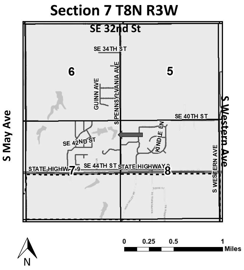
PUBLIC NOTICE
Published in the Newcastle Pacer on Thursday, October 9, 2025
Notice is hereby given of the intent to rezone a parcel of land in that part of Newcastle described as follows:
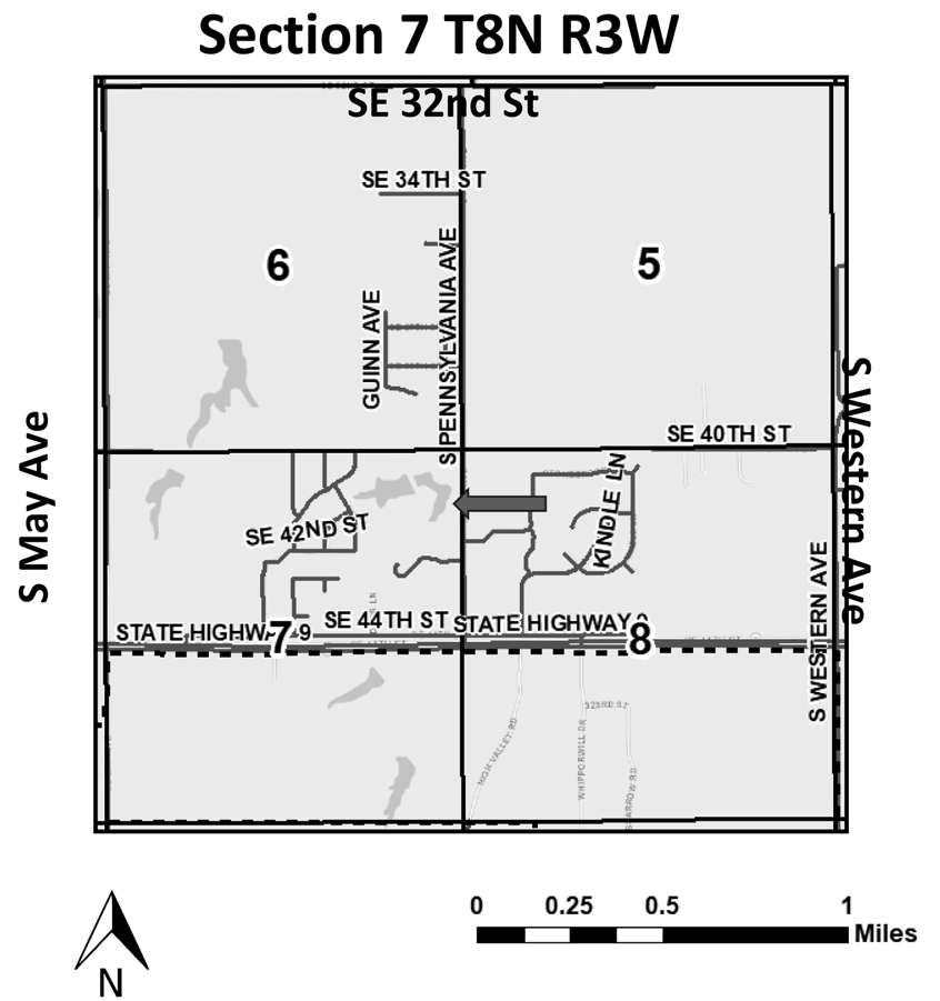
A parcel of land located in the North 365.00 feet of the South Half of the Northeast Quarter of the Northeast Quarter (S½ NE¼ NE¼) of Section Seven (7), Township Eight (8) North, Range Three (3) West of the Indian Meridian, McClain County, Oklahoma, being described as follows: Beginning at the NE/Corner of the S½ NE¼ NE¼; thence South and along the East line of said NE¼ for a distance of 120.00 feet to the Point of Beginning; thence West for a distance of 365.00 feet; thence South for a distance of 120.00 feet; thence East for a distance of 365.00 feet to a point on the East line of said NE¼; thence North for a distance of 120.00 feet to the Point of Beginning. (Hidden Haven R2025-014)
This property is located at: 4101 S. Pennsylvania Avenue, Newcastle, Oklahoma.
And is to be rezoned from E-3/A (Residential Estate District/Agriculture) to E-3 (Residential Estate District) and is owned by Hidden Haven Homes, LLC.
Anyone having any objection to this move will be heard at the regularly scheduled meeting of the Newcastle Planning & Zoning Commission on October 27, 2025, at 6:00 p.m., and the City Council on November 10, 2025 , at 6:00 p.m. Both meetings will be held in the Newcastle Multi-Purpose Center, 705 NW 10th Street, Newcastle, Oklahoma.
Gordon Harness
Chairman, Planning &
Zoning Commission
ATTEST:
Kathy James, Planning Secretary
Disclaimer: This vicinity map is for informational purposes only and is NOT suitable for legal, surveying, or engineering purposes. The City of Newcastle is not responsible for any errors, deficiencies, defects, omissions, or inaccuracies in the data.
_____________________________________________________________________
No. 109
October 9, 2025
1 time
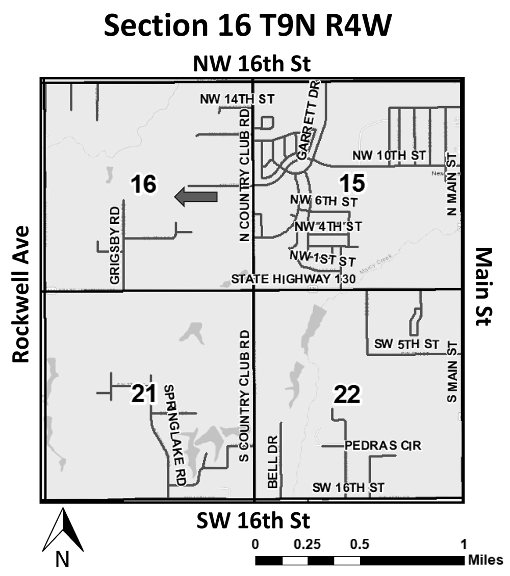
PUBLIC NOTICE
Published in the Newcastle Pacer on Thursday, October 9, 2025
Notice is hereby given of the intent to rezone a parcel of land in that part of Newcastle described as follows:
The Northwest Quarter of the Northwest Quarter of the Southeast Quarter (NW/4 NW/4 SE/4) and the West Half of the Northeast Quarter of the Northwest Quarter of the Southeast Quarter (W/2 NE/4 NW/4 SE/4) of Section Sixteen (16), Township Nine (9) North, Range (4) West, McClain County, Oklahoma (Houser R2025-013)
This property is located at: 1950 NW 8th Street, Newcastle, Oklahoma.
And is to be rezoned from E-1 (Suburban Estate Residential) to A (Agriculture) and is owned by Matthew Houser and Angel Houser, husband and wife.
Anyone having any objection to this move will be heard at the regularly scheduled meeting of the Newcastle Planning & Zoning Commission on October 27, 2025, at 6:00 p.m., and the City Council on November 10, 2025, at 6:00 p.m. Both meetings will be held in the Newcastle Multi-Purpose Center, 705 NW 10th Street, Newcastle, Oklahoma.
Gordon Harness
Chairman, Planning &
Zoning Commission
ATTEST:
Kathy James, Planning Secretary
Disclaimer: This vicinity map is for informational purposes only and is NOT suitable for legal, surveying, or engineering purposes. The City of Newcastle is not responsible for any errors, deficiencies, defects, omissions, or inaccuracies in the data.
_______________________________________________________________
No. 110
October 9, 2025
1 time
PUBLIC NOTICE
Published in the Newcastle Pacer on Thursday, October 9, 2025
Notice is hereby given of the intent to rezone a parcel of land in that part of Newcastle described as follows:
A parcel of land located in the North 365.00 feet of the South Half of the Northeast Quarter of the Northeast Quarter (S½ NE¼ NE¼) of Section Seven (7), Township Eight (8) North, Range Three (3) West of the Indian Meridian, McClain County, Oklahoma, being described as follows: Beginning at the NE/Comer of the S½ NE¼ NE¼; thence West and along the North line of said North 365.00 for a distance of 365.00 feet; thence South for a distance of 120.00 feet; thence East for a distance of 365.00 feet to a point on the East line of said NE¼; thence North for a distance of 120.00 feet to the Point of Beginning. (Hidden Haven R2025-015)
This property is located at: 4059 S. Pennsylvania Avenue, Newcastle, Oklahoma.
And is to be rezoned from E-3/A (Residential Estate District/Agriculture) to E-3 (Residential Estate District) and is owned by Hidden Haven Homes, LLC.
Anyone having any objection to this move will be heard at the regularly scheduled meeting of the Newcastle Planning & Zoning Commission on October 27, 2025, at 6:00 p.m., and the City Council on November 10, 2025 , at 6:00 p.m. Both meetings will be held in the Newcastle Multi-Purpose Center, 705 NW 10th Street, Newcastle, Oklahoma.
Gordon Harness
Chairman, Planning &
Zoning Commission
ATTEST:
Kathy James, Planning Secretary
Disclaimer: This vicinity map is for informational purposes only and is NOT suitable for legal, surveying, or engineering purposes. The City of Newcastle is not responsible for any errors, deficiencies, defects, omissions, or inaccuracies in the data.
_________________________________________________________
No. 111
October 9, 2025
1 time
PUBLIC NOTICE
Published in the Newcastle Pacer on Thursday, October 9, 2025
Notice is hereby given of a Notice for Use Permitted on Review for a parcel of land in that part of Newcastle described as follows:
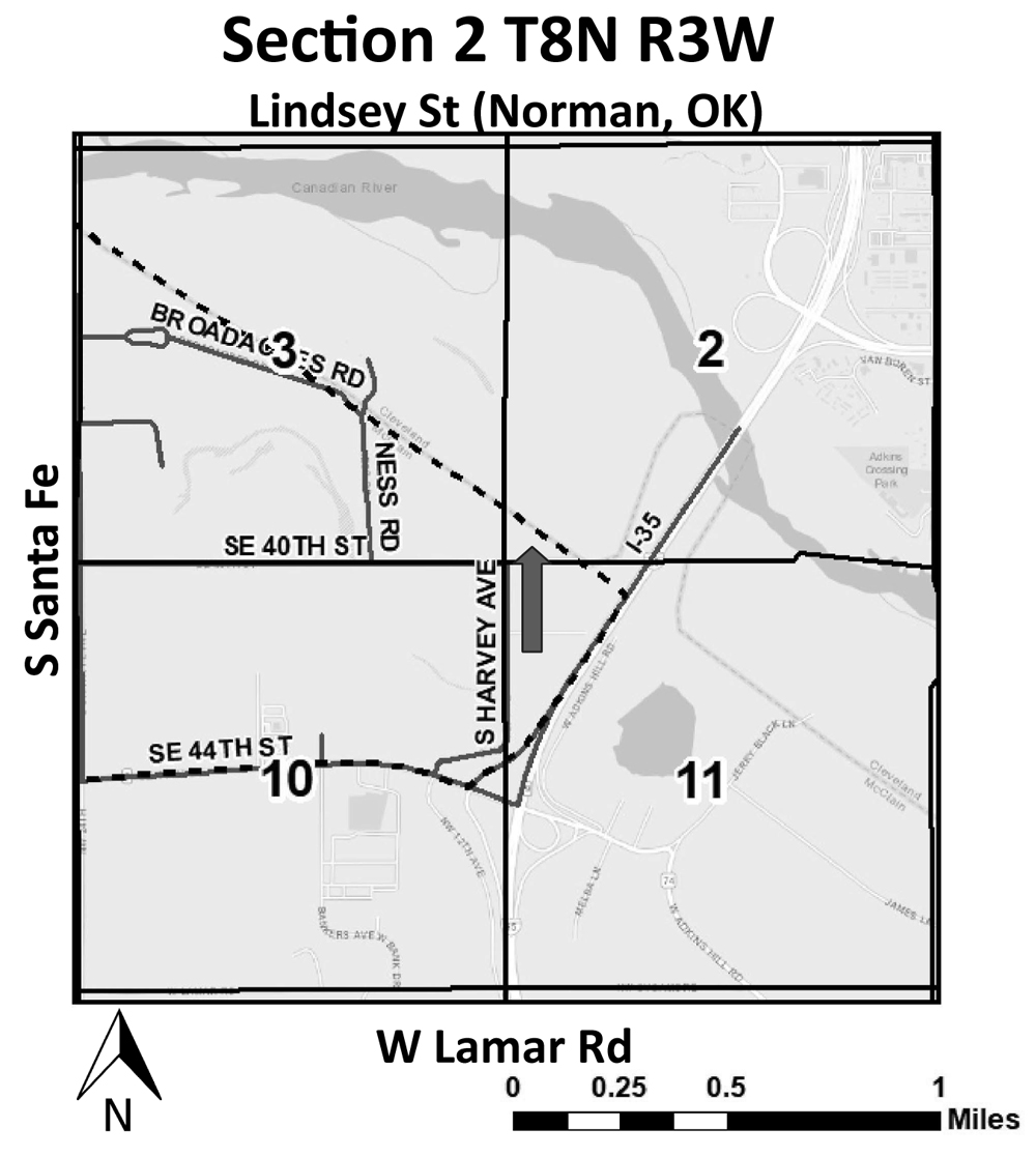
Lots Fourteen (14), Fifteen (15) and Sixteen (16) of Section Two (2), Township Eight (8) North, Range Three (3) West of the lndian Base and Meridian, McClain County, Oklahoma,
AND
BEGINNING at the SW corner of the West Half (W/2) of Section Two (2), Township Eight (8) North, Range Three (3) West of the Indian Base and Meridian, McClain County, Oklahoma; Thence North 0°11’21” West along the West line of said Section 2, a distance of 4812.37 feet to a point in the South Canadian River being midway between the present left and right row banks of the river; Thence on a meander line midway between the present right and left low banks of the South Canadian River, South 73°42’09” East a distance of 258.20 feet; Thence South 44°10’27” East a distance of 320.38 feet; Thence South 34°20’14” East a distance of
401.47 feet; Thence South 50°29’01” East a distance of 1023.53 feet; Thence South 62°12’06” East a distance of 215.48 feet; Thence South 39°34’04” East a distance of 384.38 feet; Thence South 43°46’44” East a distance of 895.71 feet; Thence South 38°10’32” East a distance of
423.03 feet; Thence South 2°46’29” East a distance of 664.78 feet; Thence South 31°08’58” East a distance of 311.28 feet; Thence South 48°00’43” East a distance of 824.60 feet: Thence South 50°58’08” East a distance of 548.07 feet to a point on the meander line midway between the right and left low banks of the South Canadian River; Thence South 39°01’52” West to a point on the South line of said Section 2, Township 8 North, Range 3 West and the right low bank of the South Canadian River a distance of 376.80 feet; Thence South 89°31’57” West along the South line of said Section 2, Township 8 North, Range 3 West a distance of 3783.20 feet to the POINT OF BEGINNING,
LESS AND EXCEPT:
BEGINNING at the SW corner of Section Two (2), Township Eight (8) North, Range Three (3) West of the lndian Base and Meridian, McClain County, Oklahoma; Thence North a distance of 66.0 feet; Thence North 89°33’06” East a distance of 904.62 feet to the P.C. of a curve to the left having a central angle of 12°00’00” degrees and a radius of 444.431 feet; Thence along said curve, a distance of 93.08 feet to the P.T.; Thence North 77°3’06” East a distance of 468.48 feet to the P.C. of a curve to the right having a central angle of 41°00’00” and a radius of 442.244 feet; Thence along said curve a distance of 316.46 feet to the P.T.; Thence South 61°26’54” East a distance of 52.72 feet to the P.C. of a curve to the left having a central angle of 29°00’00” and a radius of 285.308 feet; Thence along said curve a distance of 144.41 feet to the P.T; thence North 89°33’06” East a distance of 692.89 feet to a point on the East line of the SW/4 of said Section 2, said point being North a distance of 66.0 feet from the SE corner of said SW/4; Thence North 89°43’39” East a distance of 585.22 feet: Thence South a distance of 66.0 feet; Thence South 89°39’56” West a distance of 150.0 feet; Thence South 89°44’56” West a distance of 435.60 feet to the SE corner of the SW/4 of said Section 2; Thence South 89°33’06” West a distance of 2638.38 feet to the POINT OF BEGINNING. (Owen UPOR2025-007)
This property is located at: 3976 S. Harvey Avenue, Newcastle, Oklahoma
And is to be reviewed for the use of Precast Concrete Manufacturing Plant and is owned by D. Owen Properties, LLC/Derry Owen.
Anyone having any objection to this move will be heard at the regularly scheduled meeting of the Newcastle Planning & Zoning Commission on October 27, 2025, at 6:00 p.m., and the City Council on November 10, 2025, at 6:00 p.m. Both meetings will be held in the Newcastle Multi-Purpose Center, 705 NW 10th Street, Newcastle, Oklahoma.
Gordon Harness
Chairman, Planning &
Zoning Commission
ATTEST:
Kathy James, Planning Secretary
Disclaimer: This vicinity map is for informational purposes only and is NOT suitable for legal, surveying, or engineering purposes. The City of Newcastle is not responsible for any errors, deficiencies, defects, omissions, or inaccuracies in the data.
_________________________________________________________________
No. 112
October 9, 2025
1 time
PUBLIC NOTICE
Published in the Newcastle Pacer on Thursday, October 9, 2025
Notice is hereby given of the intent to rezone a parcel of land in that part of Newcastle described as follows:
Lots Fourteen (14), Fifteen (15) and Sixteen (16) of Section Two (2), Township Eight (8) North, Range Three (3) West of the lndian Base and Meridian, McClain County, Oklahoma,
AND
BEGINNING at the SW corner of the West Half (W/2) of Section Two (2), Township Eight (8) North, Range Three (3) West of the Indian Base and Meridian, McClain County, Oklahoma; Thence North 0°11’21” West along the West line of said Section 2, a distance of 4812.37 feet to a point in the South Canadian River being midway between the present left and right row banks of the river; Thence on a meander line midway between the present right and left low banks of the South Canadian River, South 73°42’09” East a distance of 258.20 feet; Thence South 44°10’27” East a distance of 320.38 feet; Thence South 34°20’14” East a distance of
401.47 feet; Thence South 50°29’01” East a distance of 1023.53 feet; Thence South 62°12’06” East a distance of 215.48 feet; Thence South 39°34’04” East a distance of 384.38 feet; Thence South 43°46’44” East a distance of 895.71 feet; Thence South 38°10’32” East a distance of
423.03 feet; Thence South 2°46’29” East a distance of 664.78 feet; Thence South 31°08’58” East a distance of 311.28 feet; Thence South 48°00’43” East a distance of 824.60 feet: Thence South 50°58’08” East a distance of 548.07 feet to a point on the meander line midway between the right and left low banks of the South Canadian River; Thence South 39°01’52” West to a point on the South line of said Section 2, Township 8 North, Range 3 West and the right low bank of the South Canadian River a distance of 376.80 feet; Thence South 89°31’57” West along the South line of said Section 2, Township 8 North, Range 3 West a distance of 3783.20 feet to the POINT OF BEGINNING,
LESS AND EXCEPT:
BEGINNING at the SW corner of Section Two (2), Township Eight (8) North, Range Three (3) West of the lndian Base and Meridian, McClain County, Oklahoma; Thence North a distance of 66.0 feet; Thence North 89°33’06” East a distance of 904.62 feet to the P.C. of a curve to the left having a central angle of 12°00’00” degrees and a radius of 444.431 feet; Thence along said curve, a distance of 93.08 feet to the P.T.; Thence North 77°3’06” East a distance of 468.48 feet to the P.C. of a curve to the right having a central angle of 41°00’00” and a radius of 442.244 feet; Thence along said curve a distance of 316.46 feet to the P.T.; Thence South 61°26’54” East a distance of 52.72 feet to the P.C. of a curve to the left having a central angle of 29°00’00” and a radius of 285.308 feet; Thence along said curve a distance of 144.41 feet to the P.T; thence North 89°33’06” East a distance of 692.89 feet to a point on the East line of the SW/4 of said Section 2, said point being North a distance of 66.0 feet from the SE corner of said SW/4; Thence North 89°43’39” East a distance of 585.22 feet: Thence South a distance of 66.0 feet; Thence South 89°39’56” West a distance of 150.0 feet; Thence South 89°44’56” West a distance of 435.60 feet to the SE corner of the SW/4 of said Section 2; Thence South 89°33’06” West a distance of 2638.38 feet to the POINT OF BEGINNING. (Owen R2025-016)
This property is located at: 3976 S. Harvey Avenue, Newcastle, Oklahoma.
And is to be rezoned from I-R (Restricted Light Manufacturing and Warehousing District) to I-H-2 (Heavy Industry District) and is owned by D. Owen Properties, LLC/Derry Owen.
Anyone having any objection to this move will be heard at the regularly scheduled meeting of the Newcastle Planning & Zoning Commission on October 27, 2025, at 6:00 p.m., and the City Council on November 10, 2025, at 6:00 p.m. Both meetings will be held in the Newcastle Multi-Purpose Center, 705 NW 10th Street, Newcastle, Oklahoma.
Gordon Harness
Chairman, Planning &
Zoning Commission
ATTEST:
Kathy James, Planning Secretary
Disclaimer: This vicinity map is for informational purposes only and is NOT suitable for legal, surveying, or engineering purposes. The City of Newcastle is not responsible for any errors, deficiencies, defects, omissions, or inaccuracies in the data.
______________________________________________________________
No. 113
October 9, 2025
1 time
Board of McClain County Commissioners met in regular session on Monday, 9/29/2025 at 8:19 a.m. in Room 111 of the McClain County Courthouse. Chairman Wilson Lyles called the meeting to order and led the flag salute. County Clerk Rebekah Couch called the roll and those present were: Chairman Wilson Lyles, Vice Chairman Terry Daniel, and Member Glen Murray.
Terry Daniel moved to approve the minutes from 9/22/2025, Glen Murray seconded. Vote Aye: Murray, Lyles, Daniel. Motion carried.
Terry Daniel moved, Glen Murray seconded to approve the following salary, travel, and maintenance & operation claims. Vote Aye: Murray, Lyles, Daniel. Motion carried.
CLAIMS FOR FISCAL YEAR 2022-2023 AS FOLLOWS:
ARPA 2021 165, Turn Key Health Clinics, 9185.54, Medical Staffing;
CLAIMS FOR FISCAL YEAR 2024-2025 AS FOLLOWS:
ARPA 2021 26, Town Of Wayne, 14644.87, Repair;
Rural Fire-ST 330, Stolz Telecom, 6721.50, Radios;
CLAIMS FOR FISCAL YEAR 2025-2026 AS FOLLOWS:
Extension-ST 33, OSU Cooperative Extension Service, 22666.66, Payroll;
Fair Board 2, Sheehy Signs, 2306.00, Banners;
Fair Main-ST 37, Sheehy Signs, 920.00, Banners;
General 394, Amazon, 313.91, Supplies 395, Communityworks Cleveland Co, 1881.00, Juvenile Service 396, Express Services, 1218.24, Contract Labor 397, Galls, 81.57, Jackets 398, Mollmans Water Conditioning, 552.25, Solar Salt 399, Newcastle Pacer, 295.35, Minutes 400, ONG, 338.71, Service 401, OMECORP, 644.00, Postage Supplies 402, Total Assessment Solutions, 7625.00, Contract Services 403, M Rugged Mobile Technology, 494.99, Radio Accessories;
General Govt-ST 17, KellPro, 489.00, Time Clock;
Health 75, OSDH, 27366.04, Payroll;
Highway 411, Advanced Workzone, 99.00, Signs 412, Amazon, 775.48, Supplies 413, Classic Paper, 229.50, Supplies 414, Continental Gateway, 291.00, Millings 415, Continental Gateway, 1177.75, Materials 416, Dill Oil, 18677.50, Fuel 417, Dietz Welding & Bridge Construction, 58000.00, Bridge Construction 418, Dub Ross Company, 1592.40, Tinhorns 419, Edwards Canvas, 85.00, Repair 420, Ergon Asphalt And Emulsions, 250.00, Demurrage Charge 421, Ergon Asphalt And Emulsions, 25138.01, CRS2+ 422, Great Western Trailer, 157.20, Parts 423, HAC, 93.86, Supplies 424, Hampel Oil Distributors, 619.61, Oil 425, ImageNet Consulting, 45.97, Copier Lease 426, LA Jacobson Concrete, 3567.30, Concrete 427, NAPA Auto & Truck Parts, 539.38, Parts 428, ODOT, 1655.36, Lease Purchase 429, The Stock Exchange Bank, 1188.14, Lease Purchase 430, The Stock Exchange Bank, 1467.75, Lease Purchase 431, The Stock Exchange Bank, 1758.05, Lease Purchase 432, Security State Bank, 2656.93, Lease Rental 433, Security State Bank, 2654.44, Lease Rental 434, Okla Dept Of Transportation, 980.95, Lease Purchase 435, Security State Bank, 996.11, Lease Purchase 436, SNB Bank, 919.62, Lease Purchase 437, The Stock Exchange Bank, 1131.42, Lease Purchase 438, Security State Bank, 2482.90, Lease Purchase 439, Security State Bank, 2608.01, Lease Purchase 440, Welch State Bank, 2215.98, Lease Purchase 441, ODOT, 1439.58, Lease Purchase 442, ODOT, 1233.25, Lease Purchase 443, ODOT, 1808.94, Lease Purchase 444, ODOT, 1808.94, Lease Purchase 445, ODOT, 1983.82, Lease Purchase 446, OEC, 500.00, Service 447, Trinitas Materials, 26166.00, Asphalt Laid In Place 448, Trinitas Materials, 104187.03, Type B Mix 449, T&W Tire, 2433.38, Tires 450, United Ag & Turf, 11939.22, Parts & Labor 451, United Ag & Turf, 992.54, Parts 452, Warren CAT, 1149.55, Service 453, Wayne Public Works, 140.47, Service;
Law Library 7, Parton, Laura Susan, 184.70, Payroll 8, McClain Bank, 30.60, Payroll;
ML Fee 16, Amazon, 19.29, Supplies 17, OSU-CTP, 40.00, Training;
Mtg Cert 3, CODA, 100.00, Conference;
Preservation 4, KellPro, 300.00, Credit Card Integration 5, KellPro, 252.00, Service;
Rental of County Property - Expo 38, Express Services, 1188.00, Contract Labor;
Rural Fire-ST 42, AT&T, 166.93, Service 43, AT&T, 80.08, Service 44, OEC, 66.00, Service 45, ONG, 45.73, Service 46, OSU, 1750.00, Training 47, OSU-OKC, 622.90, Training 48, Semmler, John, 475.00, Service;
SFAG 32, Davison Fuels & Oil, 2923.47, Fuel 33, Davison Fuels & Oil, 2284.20, Fuel 34, WW Tire, 20.00, Tires & Tubes/Service & Supplies 35, Sysco, 2946.38, Supplies 36, Magnum Electronics, 127.00, Antenna;
Sheriff Commissary 8, Amazon, 419.00, Supplies;
Sheriff Service Fee 68, ImageNet Consulting, 303.37, Service 69, Qualification Targets, 354.42, Supplies;
SR Cit-ST 90, Coley, Rebecca, 500.00, Contract Labor 91, Grimsleys, 78.20, Supplies 92, HD Plumbing & Construction, 300.00, Service 93, OEC, 183.76, Service.
Terry Daniel moved to approve Blanket Purchase Orders as on file in the County Clerk’s office, seconded by Glen Murray. Vote Aye: Murray, Lyles, Daniel. Motion carried.
Terry Daniel moved, Glen Murray seconded to approve the following Transfers of Appropriations: Rural Fire-ST: $30,000.00 from 1321-2-8201-4110 to 1321-2-8201-2005; Fair Main-ST: $5,000.00 from 131048047 -4110 to 1310-4-8047-2015, $10,000.00 from 1310-4-8047-2005 to 131048047-2015. Vote Aye: Murray, Lyles, Daniel. Motion carried.
Terry Daniel moved, Glen Murray seconded to approve of the following Cash Fund Estimate of Needs and Requests for Appropriations: Assr Rev Fee, CBRI, County Community Safety Investment, Fair Board, Highway, Jail, ML Fee, Mtg Cert, Preservation, Rental of County Property, Sheriff Commissary, Sheriff Service Fee, Trash Cop, Eco Dev-ST, Em Mgmt-ST, Extension-ST, Fair Main-ST, General Govt-ST, Rural Fire-ST, Sheriff-ST, Sr Cit-ST. Vote Aye: Murray, Lyles, Daniel. Motion carried.
Terry Daniel moved, Glen Murray seconded to approve of the following Lapses from 2024/2025 Appropriations & Transfers into the 2025/2026 Appropriations: ML Fee, Rental of County Property, Extension-ST, Rural Fire-ST. Vote Aye: Murray, Lyles, Daniel. Motion carried.
No Road Crossing Permits or Resolution for Disposing of Equipment were requested.
Terry Daniel moved, Glen Murray seconded to approve SA&I form 240 for an error correction requiring an adjustment to revenue between Sheriff Service Fees and General Fund. Vote Aye: Murray, Lyles, Daniel. Motion carried.
Terry Daniel moved to approve the Quartix agreement and order confirmation for the Expo Vehicle with an annual cost of $130.00, Glen Murray seconded. Vote Aye: Murray, Lyles, Daniel. Motion carried.
Glen Murray moved to approve the REAP grant request for payment, non-collusion affidavit, and contract closeout certification for District One, Terry Daniel seconded. Vote Aye: Murray, Lyles, Daniel. Motion carried.
Terry Daniel moved to the State of Oklahoma Department of Emergency Management single audit requirement notification form for Fiscal Year 2025, Glen Murray seconded. Vote Aye: Murray, Lyles, Daniel. Motion carried.
Glen Murray moved, Terry Daniel seconded to resolve to advertise to bid for Screened Decomposed Granite Delivery for McClain County District One with bids to be received by 4:00 p.m. on October 10, 2025 and opened at 8:30 a.m. on October 14, 2025. Vote Aye: Murray, Lyles, Daniel. Motion carried.
At 9:00 a.m. Terry Daniel moved to recess to conduct the EDA & CGA Meetings, Glen Murray seconded. Vote Aye: Murray, Lyles, Daniel. Motion carried.
At 9:18 a.m. on 9/29/2025 Terry Daniel moved to reconvene the BOCC meeting, Glen Murray seconded. Vote Aye: Murray, Lyles, Daniel. Motion carried.
John Shirley and Chad Masoner with Johnson Controls met with the Board to present and discuss estimates for a heat and air system upgrade at the courthouse. Mr. Shirley first proposed a turnkey solution designed to address the humidity issues in the attic space above the second floor. The proposal includes the installation of motorized louvers, high-velocity fans, and both humidity and temperature sensors. The estimated cost of this project is $191,951.55. Secondly, Johnson Controls presented a turnkey solution for replacing the two existing chillers and twenty-eight fan coil units throughout the courthouse. The proposal includes the installation of two new chillers, relocation of the power supply as discussed with the City of Purcell, construction of a new concrete pad with a protective fence for the chillers, replacement of all fan coil units within the courthouse, and an update to the Metasys system. The estimated cost of this project is $1,278,200.11. No action was taken.
At 10:04 a.m. Terry Daniel moved to recess to 1:00 p.m. on 9/29/2025 to meet with the Excise Board and Floyd & Driver, Glen Murray seconded. Vote Aye: Murray, Lyles, Daniel. Motion carried.
At 1:22 p.m. on 9/29/2025 Terry Daniel moved, Glen Murray seconded to reconvene the BOCC meeting to attend the Excise Board Meeting with all members present. Vote Aye: Murray, Lyles, Daniel. Motion carried.
BOCC met with the Excise Board Chairman Bill Hammon, Vice Chairman Sandy Logan, Member Trisha Scott, and County Clerk Rebekah Couch to discuss the budget for the 2025-2026 fiscal year. Terry Daniel moved to acknowledge the Excise Board’s decision to set the budget for the 2025-2026 fiscal year, Glen Murray seconded. Vote Aye: Murray, Lyles, Daniel. Motion carried.
David Floyd met with the Board and discussed the utilization of projected sales tax revenues from the sales tax extension approved by the McClain County voters on September 9, 2025. No action taken.
With no further business Terry Daniel moved to adjourn at 3:11 p.m., Glen Murray seconded. Vote Aye: Murray, Lyles, Daniel. Motion carried.
BOARD OF COUNTY
COMMISSIONERS
McCLAIN COUNTY, OKLAHOMA
Glen Murray, Chairman
Wilson Lyles, Vice Chairman
Glen Murray, Member
Attest:
Rebekah Couch
County Clerk
_____________________________________________________________